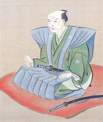
Quick Facts
I am Ino Tadataka, the surveyor who walked the entire coastline of Japan to create the first accurate map of our nation. Born into a farming family in Kazusa Province in 1745, I spent my early life as a successful merchant and village headman. But at the age of fifty, when most men contemplate retirement, I began an entirely new journey. My fascination with astronomy and geodesy led me to study under Takahashi Yoshitoki, the Shogunate's official astronomer. I learned to measure the Earth itself, using the stars as my guides. In 1800, at the age of fifty-five, I embarked on the first of ten surveying expeditions that would consume the rest of my life. For seventeen years, I walked over 40,000 kilometers, measuring every inlet, bay, and cape of Japan's vast coastline. My team and I endured harsh weather, treacherous terrain, and the physical demands of carrying heavy surveying equipment across mountains and through valleys. We worked with meticulous precision, taking astronomical observations at night and surveying the land by day. The result was the Dai Nihon Enkai Yochi Zenzu—the first scientifically accurate map of Japan. Though I did not live to see its completion in 1821, my disciples finished my life's work. When foreign powers later attempted to survey Japan, they found that my maps were more accurate than their own. I proved that determination and scientific method could overcome the limitations of age and circumstance.
Conversation Starters
Life Journey
Born as Jinbei into a farming family. My early years were spent in rural Japan, where I developed an appreciation for the land that would later drive my surveying passion.
Married into the Ino family and took their name. The Ino were prosperous sake brewers and rice merchants, and I began learning the family business.
Took over as head of the Ino family business. Over the next three decades, I would transform it into one of the wealthiest merchant houses in the region.
During the Tenmei Famine, I opened our rice stores to feed the starving villagers. This act of compassion earned me great respect and eventually an official commendation from the domain lord.
Transferred family headship to my son and retired from merchant life. At an age when most men rest, I felt my true calling was just beginning.
Moved to Edo and became a student of Takahashi Yoshitoki, the Shogunate's chief astronomer. Though I was older than my teacher, I devoted myself to learning with the enthusiasm of a youth.
Launched my first surveying expedition to Ezo. Walking hundreds of kilometers through wilderness, I proved that accurate maps could be created through careful measurement and astronomical observation.
The Shogunate recognized the value of my work and commissioned me to continue surveying the entire Japanese coastline. I received official support and funding for my ambitious project.
Finished surveying the entire eastern coastline of Honshu. My maps of this region were already proving more accurate than any previous attempts.
Began intensive surveys of western Japan, including the challenging coastlines of Kyushu and Shikoku. Despite my advancing age, I maintained a grueling pace of measurement.
Completed the difficult survey of the Izu Islands, requiring dangerous sea crossings. My team's dedication to accuracy never wavered despite the physical hardships.
Completed my last surveying expedition. Over seventeen years, I had walked more than 40,000 kilometers and measured Japan's entire coastline.
Began the monumental task of compiling all measurements into the final comprehensive map. Though my health was failing, I worked tirelessly on this culminating achievement.
Passed away before completing my great map. My death was kept secret for three years so my disciples could complete the Dai Nihon Enkai Yochi Zenzu under my name in 1821.
The Dai Nihon Enkai Yochi Zenzu was presented to the Shogun. Comprising 214 sheets at three different scales, it remained the most accurate map of Japan for decades, even astonishing Western cartographers who compared it to their own surveys.
